|
DAVETREK ADVENTURES |
|
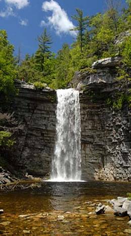
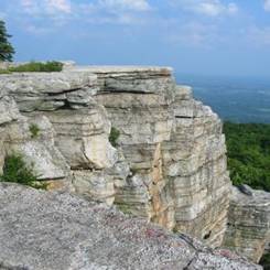
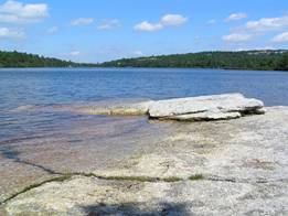
6/16/13 ‘Gunks’, Cliffs & Waterfall Hike + Swim ‘n Din Sams Point ( longer hike) Awosting Falls (Left, shorter and longer hike) Lake Minnewaska ( swimming) RSVP AT THE BOTTOM OF THE PAGE ON THE FORM RSVP DEADLINE, WEDNESDAY, JUNE 12 We are pleased to announce a hike for Sunday, June 16, in the glorious Gunks within Minnewaska State Park. The ’Gunks’ are the Shawangunk Ridge, a stunning set of mountains from High Point in NJ to the Catskills. The gunks features views, exposed cliff faces, lakes and waterfalls, all of which you will get to see on the various hikes and activities. Its also a favorite hangout for rock climbers also, with some of the best rock climining and bouldering in the NY area. This is a very popular park, where the parking lots fill up quickly, often before 11 am. Its about 100 miles away, about 1 hr and 45 minutes to 2 hrs north from New York City, but well worth the trip! We intend to have two hikes A) Castle Point - Longer Hike - 9 to 10 miles, 1200 + feet of elevation, limited number of people, for experienced hikers only. The hike will cross some streams, have some spectacular vistas including Castle Point ( above) one of the most scenic spots in the entire Gunks. I have not set the exact hike yet, here is a hike description that will be comparable to the hike we will do. It’s a solid moderate to strenuous hike, a 7 on a scale of 1 to 10. We will limit the people who can do this hike to those with proven hiking experience. We will also visit Awosting Falls (above). B) Beacon Hill/Lake Minnewaska—Shorter Hike. We also hope to have a shorter hike, 3 to 5 miles. Here is a version of the hike that we will likely do. Those doing the shorter hike will also have the chance to go to Awosting Falls, pictured above. I am still looking for someone to lead this hike and be the sweep for this hike - those two people will not be charged the event fee. A. B. Both groups will also have the option to go swimming at Lake Minnewaska, a very deep and clear lake celebrated as one of the Sky Lakes, and to visit Awosting Falls, pictured above. C. D. You may also sign up just to come for the day and not hike, just relax in the park and at the lake. E. We will also have a light pareve and dairy meal together. This is an all day affair, from 8am when you leave until we leave the park around 7pm and get home around 9pm or later. F. G. The cost of the event is $19 per adult, $9 per child, which includes our standard $5 per event fee. H. I. There is also an $8 per car fee to enter the park, so keep that in mind as a driver and if you take at least 3 passengers, you will have all of your driving, tolls and entrance fees paid for! See the details below J. K. L. Main Details M. N. DATE: Sunday, June 16, 2010 O. P. MEETING TIME: Meet at hike location no later than 10:00 AM. The parking lots at Lake Minnewaska fill up by between 10 and 10:30 am, and other nearby lots fill by 11 am, so don't be late! I plan to leave close to this time, so do not come late or you will miss us. Q. R. If driving, leave no later than 8:00 AM from any NY city location, as it will take everyone at least 1 hr and 45 minutes to 2 hrs to get there . See Directions, below for driving time and leaving time details. S. T. END TIME: The shorter hike should finish no later than 2 PM, and the longer hike should finish by 4:30/ 5PM, leaving time for swimming and dinner, depending on people’s pace and how long lunch takes. U. V. COSTS: $19 per adult, $9 per child. W. X. If you get a ride, then pay your driver $20 for transportation/park entrance fees,. There is also an $8 entrance fee to the park, which is covered as part of the ride fee for drivers who take at least 3 passengers. Y. Z. There are NO REFUNDS unless we cancel the event because of weather or other concerns. You may sell your ticket to someone else, though - just let us know if you do this so we can properly register your replacement. AA. BB. CC. RSVP - On the form at the bottom of this page. Please RSVP no later than Wednesday, June Thanks! DD. EE. DIRECTIONS AND DRIVING/ LEAVING TIMES: FF. GG. Here is the park Map link to the entrance to the park, approximately at the spot where there is a park toll booth. Just enter you address and you will get a google map to the park. There is an $8 per car entrance fee. We will meet at the parking lot for Lake Minnewaska, which is uphill about 0.4 mile from the entrance to the park. If this parking lot is full when you come, park in ones nearby and come to the Lake Minnewaska parking lot. HH. II. JJ. DRIVING/LEAVING TIMES KK. LL. Here are the suggested leaving times: MM. NN. Manhattan, Riverdale, Queens ( KGH, Forest Hills), Northern NJ (Teaneck, Passaic) - 1:45 minutes to 2 Hrs, leave no later than 8:00 AM OO. PP. Brooklyn, Long Island, Central NJ - 2hrs to 2 hrs 15 minutes, leave no later than 7:45 AM QQ. RR. WHAT DO I NEED TO BRING? (please read!) SS. TT. Good hiking shoes, preferably hiking boots, hat, suntan lotion, bug spray, LUNCH, 2 liters of water minimum ( those who do not have 2 liters at the hike trail head will not be allowed to go on the hike, so bring extra water if you plan to drink some in the car!), windbreaker/extra top layer if its chilly, though right now the weather looks to be in the High 70s and sunny! Rain in the forecast will alter or cancel this event. I will update the weather for those coming as of the deadline. UU. VV. Hike links & descriptions WW. A) Castle Point - here is a hike description that will be comparable to the hike we will do. B) Beacon Hill/Lake Minnewaska—. Here is a version of the hike that we will likely do. Those doing the shorter hike will also have the chance to go to Awosting Falls, pictured above. I am still looking for someone to lead this hike and be the sweep for this hike - those two people will not be charged the event fee. HIKE RATING: Long hike— a moderate strenuous hike, a 7 on a scale of 10 - Shorter hike - a 4 on the same scale, an easy to moderate hike, with some elevation feet of elevation, 3 to 5 miles - if you can walk 5 miles comfortably, consider coming even if its your first hike. The height variations do make it harder than a simple walk in the park though... WEATHER Any rain in the forecast will cause a cancellation. Right now there is chance of rain, but its way to early to know what the weather will be for that. I will decide on Friday, June 18, based on forecasts. Also, make sure I have a number where you can be reached Saturday Night, in case of any last minute cancellations. Fill out all of this information on the form below. RIDES & DRIVERS We will try and sort rides for this hike. If we are unable to do so because we have too many, we will perhaps rent a passenger van from Manhattan. Let us know if you can drive that on the rsvp form below. For rides, we hope to will publish information in an online spreadsheet from DRIVERS offering to provide rides for people going to the event, and invite everyone to this spreadsheet. Everyone will then be able to contact drivers and then add yourself as a passenger to the ride, once the driver is in agreement. If you need a ride, it pays to RSVP sooner, because you will have access to the ride spreadsheet earlier and can sort this out before a driver fills up! RSVP AT THE BOTTOM OF THE PAGE ON THE FORM RSVP DEADLINE, WEDNESDAY, JUNE 12 WE MAY CAP THIS EVENT AT 40 PEOPLE, SO RSVP ASAP! |